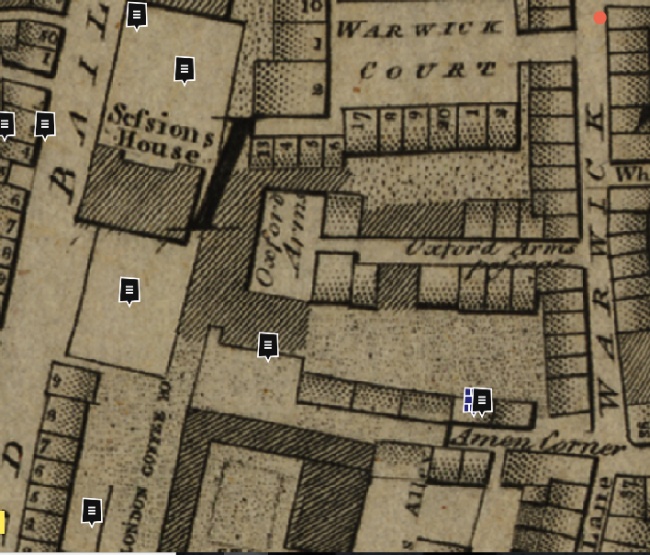
Finding where the London Wall actually is, or was situated, gets much more difficult after the Museum of London tour finsihes. Their tour ends at plaque 21 which is south of Aldersgate, in St Martins le Grand; and close to the Museum of London. The wall leads south from here. There was an very old inn called the Oxford Arms which existed in Warwick lane. It was ay the junction with 14 Warwick lane where Oxford Arms passage existed, and the Tap always gives this as the address. The Oxford Arms existed until about 1876. In the description of the Inn, it states about the London wall, as follows:
The Roman wall passes very close to the rear – “Keeping at the back of the present prison, the wall passed the ends of the College of Physicians, Warwick Square, the Oxford Arms Inn, Stationers’ Hall, and the London Coffee-house, Ludgate Hill, where it abutted at Ludgate, the distance being forty-two perches. From Ludgate it continued by Cock Court to New Bridge Street, where remains of it are at present very perceptible, whence it proceeded along the Fleet Ditch to the east side of Chatham Square and to the Thames, at the distance of one hundred and thirty perches, making up a total of two miles and six hundred and eight feet in circuit.”
This is a really good description, and archeological digs of the London wall, mostly during diggng to create sewers, confirm a lot of this detail.
The NLS ordnance survey maps side by side are also absolutely brilliant with comparisons of an older map with a modern mapping.
The last section of their post takes us to the junction of Aldersgate street (the southern end), and St Martins le Grand. It includes the site of the Mourning Bush Tavern, latterly called the Raglan Hotel, and more latterly the Lord Raglan. In Elizabethan times, it had been known as the Fountain. It is still in existence in 2021, a Greene King pub.
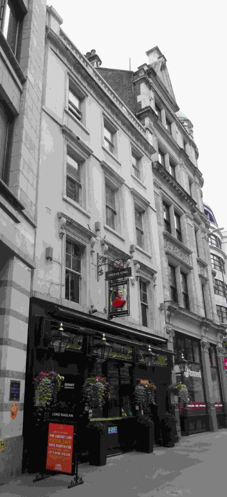
If you want a decent read about the Mourning Bush history, its on my Londonwiki site, and the pub is latterly listed on my pubwiki with even more great detail.
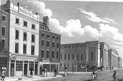
The wall then turns west and passes the other very old inn, the Bull and Mouth, latterly the Queens Hotel from 1831 to 1888. This became the exact site of the new General Post Office ; and what appears to remain of this is now the Postmans Park.
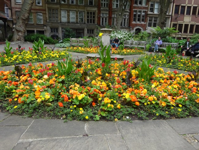
St. Botolph, Aldersgate churchyard, South side.
In 1887, in clearing a site for post-office buildings, a stretch of 131 feet of the wall was exposed. The inner face of the wall now forms the North side of the basement area. A total height of 14 feet 4 inches of Roman work was seen.
It is clear if you open the NLS maps that the wall runs along the southern side of Postmans Park. It then crosses King Edward street and across the street is St Bartholomew hospital; the site of Christs Hospital. I need to revisit the area.
Before St Bartholomew hospital meets Giltspur street, there is a passage between this building and the Bank of America and the wall would have been through the Bank of America as it turns southwards towards Newgate street.
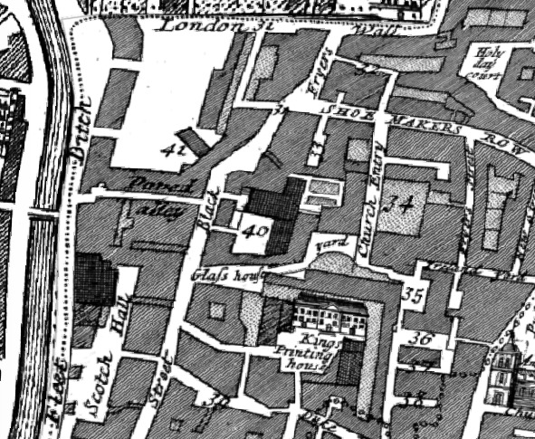
The site of the Old Bailey is exactly on top of the original Newgate Prison.. The rear of the Old Bailey is the line of the wall. My guess is that the gates visible from Newgate street hide some of this. There are guided walks to access this area, I believe. The same goes for the central criminal courts, alrthough there may be some form of access behind via Amen court, which leads in from Warwick lane, parallel and to the east of the Old Bailey. There are two sections of Amen court, the northern one was originally called Oxford Arms passage. The Oxford Arms and this section of wall seems to heve been obliterated by a large building, more to follow.
This shows the 1799 Harwood map, one of those you can view at the Layers of London site, which is very very impressive. It takes a while to get the hang of how to map a building through time, but well worth the effort.
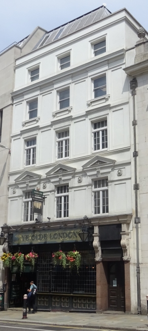
Travelling south, the London wall runs past Stationers Hall, then through an invisible gap between St Martins church and a pub in Ludgate. This is now called Ye Old London and is in the same spot as the London coffee house in Ludgate hill.
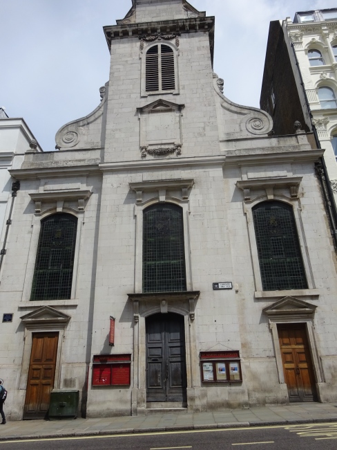
Next door, inside the Roman London wall is now St Martins Ludgate. This is the actual site of ‘Ludgate’.
The London wall, now entirely invisible runs due south from here and along Cobbs court. This is a northerly turning on Carter lane, and has existed since at least 1756 as Stow mentions it. There is a public house on the corner of Cobbs court (or Cobs court) and Carter lane. It is not the Rising Sun which is at the junction with Burgon street, and shows an early address of Shoemakers row which is in fact the early name for this section of Carter lane; ceertainly in 1860 and before. If you look at the 1799 Harwood map, Great Carter lane starts after Creed street. This is all in St Ann Blackfriars parish.
Actually, there is an Old Bailey criminal case in August 1864 of George Morris when they state “and went to Shoemaker-row, into a public-house at the corner of Cobb’s-court”, and another witness mentions this as the Blue Last. Looking at the Broadway in the 1857 directory, Cobbs court is at about 9 Broadway.
Again looking at a later directory, St Anns coffee house is on the north side of Carter lane, and in the correct position when Creed lane is at about 42 Carter lane. Incidentally, what is later called New Bridge street was earlier the Fleet Ditch, certainly very noticeable in the 1746 Rocques mapping; or Bridewell Dock in Faithorne and Newcourt map of 1658. I love early maps.
This is an Account of this Part of Farringdon Ward‘s lying within the Walls of London, containing the ancient Wards of Newgate and Ludgate in Distinction to the other Part, which was without the Walls, all in 1756.
Here is the archelogical descriptions of this area from sewer excavations:
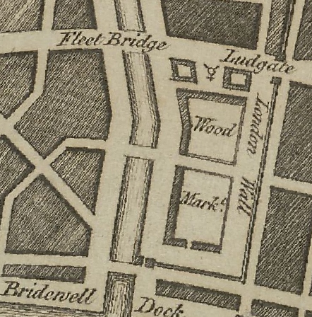
South of Ludgate, The line of the Roman wall from Ludgate to the Thames is badly recorded. Two portions, however, appear on the subjoined evidence to have continued the line from the Old Bailey southwards : —
(a) In Playhouse Yard. sewer operations show a portion of “old London wall ” was exposed. From the context it appears to have run North and South in a line with Ludgate. It was 10 feet thick and “ composed of large unhewn stones embedded in a sort of grouting composed of powdered bricks, lime and gravel.”
The wall was tunnelled through but not destroyed .
A second account of the discoveries in Playhouse Yard is contributed by “ E. B. P.” He states that a wall 8 to 10 feet thick was found near the West end of Playhouse Yard near the Apothecaries’ Hall and within 100 feet of it (presumably farther East) were two others of the same massive character, all three running North and South. Which of these walls was that seen by Mr. Chaffers is uncertain but E. B. P.’s identification of the western wall with the town-wall is obviously wrong. It is possible that all three walls were part of the Blackfriars Convent.
(b) Under the “Times” Office. The position of a fragment is indicated on a sketch-plan in the Builder, 1855, 221 and 269, showing the line of the wall South of Ludgate in its relationship to the Times building. Roach Smith describes this fragment as a very thick wall of three distinct constructions. That of the Roman city-wall ; a reparation of considerable solidity which might be Norman or Early English work ; and, above all, the remains of a passage or window which probably belonged to the Blackfriars Monastery.” The section was examined during some alterations to the buildings.
The fragment has been subsequently destroyed.